
Living in Ponsonby and Freemans Bay: a local read on Auckland's inner west
A local read on Ponsonby and Freemans Bay: where one ends and the other begins, the walk to town, Western Park, and who they suit.
At a glance
- Where
- Immediately west of the Auckland CBD
- The boundary
- Ponsonby sits on the ridge, Freemans Bay runs down the slope toward the water
- Walk to town
- Freemans Bay is within a comfortable walk of the CBD
- Open space
- Western Park, between the two
- Housing
- Victorian and Edwardian cottages and villas, with newer apartments among them
- Suits
- Buyers who want to live without depending on a car
Freemans Bay and Ponsonby don't have a fence between them, and most people who live here couldn't draw you the exact line if you asked. We built Western Park Apartments on Hopetoun Street, right where the two run into each other, so this is a first-hand read rather than a marketing gloss on a suburb map.
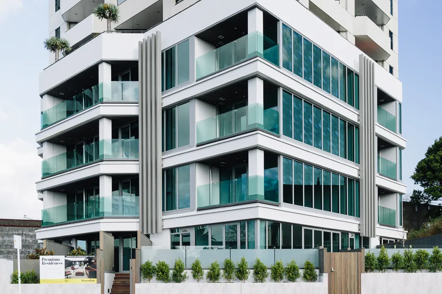
Western Park Apartments on Hopetoun Street: 27 boutique apartments Heartland completed in 2017, across the road from Western Park.
Where Ponsonby ends and Freemans Bay begins
Ponsonby is the name most people know: the ridge, the villas, and the strip of cafes and shops along Ponsonby Road. Freemans Bay sits below and to the east of it, running down toward the harbour and the motorway, with Western Park cutting through the middle of the suburb as its defining green space. The boundary between the two shifts depending on who's drawing it, and plenty of addresses get marketed under whichever name sells better, which is exactly what happened with our own building: Western Park Apartments is on the Ponsonby side of Hopetoun Street for how it's known locally, and Freemans Bay for its postal address. Both are correct. Confirm the specific detail you care about, whether that's a school zone or a council record, against the address itself rather than the suburb name.
What is the history of Ponsonby and Freemans Bay?
Neither suburb started out the way it looks today. Freemans Bay takes its name from James Stuart Freeman, secretary to Governor Hobson, who lived in the area, not from any hard living the name suggests, though the suburb earned that reputation regardless. For most of the twentieth century it was the wrong side of Queen Street: workers' cottages built cheap and close, a reputation for crime and union activity respectable Auckland kept its distance from. In 1951 the council declared 96 hectares of it a redevelopment area that would have displaced over 7,000 people. It was never fully carried out, but the pressure reshaped the place anyway.
Ponsonby's villas have the same history under fresh paint. They were built as working-class and immigrant housing, home to a large Pacific community through the mid-century, and rising rents through the 1970s and 80s pushed most of that community out as wealthier buyers moved in and restored the same houses. The buildings didn't change. Who could afford them did.
One physical landmark survives from before any of that turnover. The Ponsonby Reservoir was built in the 1880s to City Engineer William Errington's design and is still gravity-fed from the Waitākere Ranges today. The corner near it, where Ponsonby Road runs toward Karangahape Road, was known locally as Reservoir Corner as far back as 1899, the subject of a watercolour from that year now held by Auckland Art Gallery. The reservoir was rebuilt in the 1950s. The corner still carries the name.
How far is Ponsonby from the Auckland CBD?
The single biggest practical fact about this pocket of Auckland is how close it sits to the CBD. Freemans Bay runs directly up against the motorway on the city side, with Victoria Park and Wynyard Quarter within an easy walk for most addresses, and the CBD itself not far past that. For people who want to walk or cycle to work rather than drive or bus it, this is one of the few Auckland suburbs where that's a realistic daily choice rather than an aspiration.
That connectivity is about to gain a second layer. The City Rail Link's new Karanga-a-Hape Station opens in the second half of 2026, with entrances at Beresford Square and Mercury Lane, on the same Beresford Street that marks one of Western Park's own entrances. For residents, that's a new underground rail line arriving on foot rather than a drive to the nearest station.
Western Park, Ponsonby's green space
Western Park is one of Auckland's oldest parks, opened in 1879, running downhill from Ponsonby Road to Freemans Bay with entrances off Beresford, Hepburn, Hopetoun, Smith and Tahuna Streets. It carries established trees, including pūriri, tanekaha, karaka and pōhutukawa, a 1.0 kilometre loop path, two tennis courts, sports fields, fitness equipment, and a tiered playground with a 25-metre slide locals will tell you is among the longest in the city. It's the kind of established green space few inner-city apartment buildings anywhere in Auckland can walk to.
The Hopetoun Street side of the park has its own quieter feature: the Western Park View Point, land added to the park in the 1980s and re-landscaped in the early 2000s into a proper viewing platform, looking out over the Waitematā Harbour. It sits a short walk from the building's own front door.
One home in the building across the road from it is coming back to market: Penthouse 504 at Western Park, two storeys, three bedrooms, looking out toward Mount Eden.
Who does Ponsonby or Freemans Bay suit?
Professionals wanting a short commute and a walkable lifestyle are the obvious fit. Ponsonby carries the cafe side of that lifestyle properly: good food, an afternoon cocktail, and a real night life, all within walking distance rather than a drive. It also suits downsizers wanting a low-maintenance, lock-up-and-leave home without giving up green space or a walkable lifestyle. Family living here has its own honest trade-offs, weighing the park against a smaller footprint than a house would give.
The trade-off shows up on schedule. Come peak hours, the traffic is immediate and on your doorstep, not something you drive a few minutes to find. You're buying proximity to the strip and the city, and that same proximity is what backs up outside your building twice a day. If the cafes and the night life are worth that to you, few parts of Auckland offer the combination this one does.
Heartland built Western Park Apartments on Hopetoun Street in 2017 and has one home there, Penthouse 504, coming back to market. To hear about it first, register your interest.
Sources
- Auckland Council: Western Park park detail
- Auckland Council: Western Park Path
- Wikipedia: Western Park, Auckland (Western Park View Point history, Hopetoun Street land addition, harbour view)
- Heartland Developments: Western Park Apartments
- Wikipedia: Freemans Bay (name origin, 1951 redevelopment declaration, workers'-housing history)
- Wikipedia: Ponsonby, New Zealand (villas' working-class origins, 1970s-80s gentrification, Pacific community displacement)
- Engineering New Zealand: Auckland's Water Service Reservoirs (Ponsonby Reservoir, 1880s, William Errington)
- DigitalNZ / Auckland Art Gallery Toi o Tāmaki: Ponsonby Road Reservoir Corner, 1899 (Harold Young watercolour)
- Auckland Transport: Karanga-a-Hape Station (City Rail Link, 2026 opening, station entrances)
- City Rail Link: Karanga-a-Hape Station (confirms the two entrances: Mercury Lane and Beresford Square)
- Freemans Bay School: School Zone
- Auckland Girls' Grammar School: School Enrolment Zone
- 1News: Two key City Rail Link commitments confirmed ahead of opening (CRL opening timeframe, July 2026)
Questions people ask about Ponsonby and Freemans Bay
Is Freemans Bay a good place to live in Auckland?+
Yes, for people who want inner-city convenience without living in the CBD itself. Freemans Bay sits immediately west of the motorway, an easy walk to Wynyard Quarter, Victoria Park and the Ponsonby Road strip, with Western Park's established green space running through the middle of the suburb.
Is it better to live in Ponsonby or Freemans Bay?+
They're neighbouring suburbs with a blurred, shifting boundary rather than a hard line, and the honest answer is that daily life mostly doesn't distinguish between them. What matters more than which postcode you're technically in is which end of the strip you're closest to and whether you're on the park side or the road side.
What's the lifestyle like for professionals living near Auckland CBD?+
Freemans Bay and Ponsonby suit professionals who want to walk or cycle to the city rather than commute into it. Ponsonby Road's cafes and restaurants are a short walk from most addresses in both suburbs, and Wynyard Quarter and the Viaduct are close enough to reach on foot for most people.
Is Freemans Bay walkable to the city?+
Yes. Freemans Bay sits directly against the motorway on the CBD side, and most addresses are a walk of well under half an hour to the city centre, shorter again to Victoria Park and Wynyard Quarter.
What's the difference between Ponsonby and Freemans Bay as suburbs?+
Ponsonby is the better-known name and carries the retail strip along Ponsonby Road. Freemans Bay is the harbourside suburb between Ponsonby and the CBD, with Western Park as its defining green space. Some addresses, including our own Western Park Apartments, are marketed under one suburb name while sitting in the other for postal and mapping purposes, which is common in this part of Auckland and worth confirming for any specific address rather than assumed.
Who developed the Western Park apartments in Ponsonby?+
Western Park Apartments at 9 Hopetoun Street was developed by Heartland Developments in partnership with Sanctuary Group, converting an existing office building into 27 boutique apartments. It was completed in 2017 and sold out.
Why is Freemans Bay called Freemans Bay?+
It's named after James Stuart Freeman, secretary to Governor Hobson, who lived in the area in the suburb's early days. The name isn't connected to the suburb's later reputation as one of Auckland's poorer, industrial districts, that came from its history as workers' housing, not from its name.
Is a train station coming to Ponsonby or Freemans Bay?+
Not directly in either suburb, but the City Rail Link's new Karanga-a-Hape Station opens in the second half of 2026 with entrances at Beresford Square and Mercury Lane, walking distance from both suburbs and from Western Park itself.
Which entrance do I use for the City Rail Link near Western Park?+
Karanga-a-Hape Station has two entrances, Mercury Lane and Beresford Square. Beresford Square sits on the same street as one of Western Park's own entrances, making it the closer of the two on foot from the building.
Is there a lookout or view point near Western Park Apartments?+
Yes. The Western Park View Point sits on the Hopetoun Street side of the park, on land added in the 1980s and re-landscaped in the early 2000s into a viewing platform over the Waitematā Harbour. It's a short walk from Western Park Apartments' own front door.
What schools are near Ponsonby and Freemans Bay?+
Freemans Bay School and Ponsonby Primary School cover the primary years, with Ponsonby Intermediate after that. For secondary, Auckland Girls' Grammar School sits on Howe Street in Freemans Bay itself. Zones are set by each school individually and can change, so confirm any specific address directly with the school before relying on it.
Was Freemans Bay always a desirable suburb?+
No. For most of the twentieth century Freemans Bay was one of Auckland's poorer, more industrial districts, known locally as the wrong side of Queen Street, with cheap, closely built workers' cottages and a reputation for crime and union activity. In 1951 the council declared 96 hectares of it a redevelopment area that would have displaced over 7,000 residents. The plan was never fully carried out, but the pressure reshaped the suburb anyway, well before it became the address it is today.
Were Ponsonby's villas always expensive?+
No. The villas were originally working-class and immigrant housing, home to a large Pacific community through the mid-twentieth century. Rising rents through the 1970s and 80s pushed much of that community out as wealthier buyers moved in and restored the same houses. The buildings didn't change. Who could afford them did.
What is Reservoir Corner in Ponsonby?+
Reservoir Corner is the local name for the area near the Ponsonby Reservoir, where Ponsonby Road runs toward Karangahape Road. The reservoir was built in the 1880s and is still gravity-fed from the Waitākere Ranges. The name dates back to at least 1899, when the corner was the subject of a watercolour now held by Auckland Art Gallery.
About the author

James is Heartland’s development manager and the second generation of the family in the business, working across feasibility, consenting, consultant engagement and buyer research. He came to development through construction, and holds degrees in property and commerce from the University of Auckland.
Related reading
- Case studyWestern Park ApartmentsHeartland on the edge of the park between the two suburbs.
- GuideTwo levels or three storeys?Worth reading before buying anything new in the inner west.
- GuideBody corporate fees in NZWhat apartment living actually costs to run, from the developer's side.
- GuideBody corporate rulesPets, BBQs and committees: what the rules restrict and who writes them.